Kayak Camping in Algonquin Provincial Park
  • Home
  • What's New
  • Trip Logs
    • 2018 - Achray - Clover - Tarn - St. Francis >
      • Part 2: Clover to Stratton
      • Part 3: Stratton, High Falls, St. Francis
      • Part 4: Barron Canyon
    • Rock - Louisa - Welcome
    • Opeongo - Catfish
    • Kiosk - Erables - Catfish - Cedar
    • Canoe - Joe - Burnt Island
    • Canoe - McIntosh - Shah
    • Shall - Booth - Shirley - McKaskill
    • Opeongo - Shippagew
    • Opeongo - Round Island >
      • Opeongo - Round Island Part 2
    • Magnetawan - Rosebary - Shah >
      • Magnetaway - Rosebary - Shah Part 2
    • Kiosk - Mouse - Maple >
      • Kiosk - Mouse - Maple Part 2
      • Kiosk - Mouse - Maple Part 3
    • 2017: One Day Failed Trip
  • Blog
  • Gear
    • Kayak Yoke
    • Camping Checklist
  • Photo Gallery
  • About
    • Contact

Kayak Camper's Blog

All Things Kayaking and Camping (and Algonquin...ing)

Spring Fever in February...

2/15/2017

2 Comments

 
It has been 191 days since I returned from my last camping trip, and it will be at least another 80 until I can go camping again. That is NUTS. Damn you Canadian seasons coupled with life and work responsibilities. Oh and injuries. Don't forget injuries. 

For the last few weeks I've been obsessing over my first trip of 2017, to the point where I actually pulled out my camping gear and started weighing every individual thing. That's actually a useful thing to do it turns out, as it can be surprising where weight creeps in you don't really need. In my 'tent bag' is a hard glasses case which, unsurprisingly, my glasses go in. That case weighs more than 300 grams, or over half a pound! So that case is now back in my nightstand, and the tent bag now has one that weighs about 80 grams instead. Similarly I had items in my emergency bag that I've never used and didn't even have a realistic use-case for. Putting them on the scale made me realize that there's a cost to every single thing I'm throwing in "just because". I think by the time I'm done going through everything I'll be able to drop at least 3 pounds off my gear weight. Go me.

Speaking of weight, I'm also working on my own. The last two years have been all about puppy and baby, and I've been neglecting my own health. The videos I posted of my August trip made me cringe a bit when I saw just how puffy I'd gotten, so I decided it was time to do something about it. In November I started back into running. Aside from a break over the holidays (and a week missed due to illness) I've been running 5 days a week pretty consistently. As of this morning, I've lost 15 pounds. By the time of my first camping trip I intend to lose another 15. Also go me. 

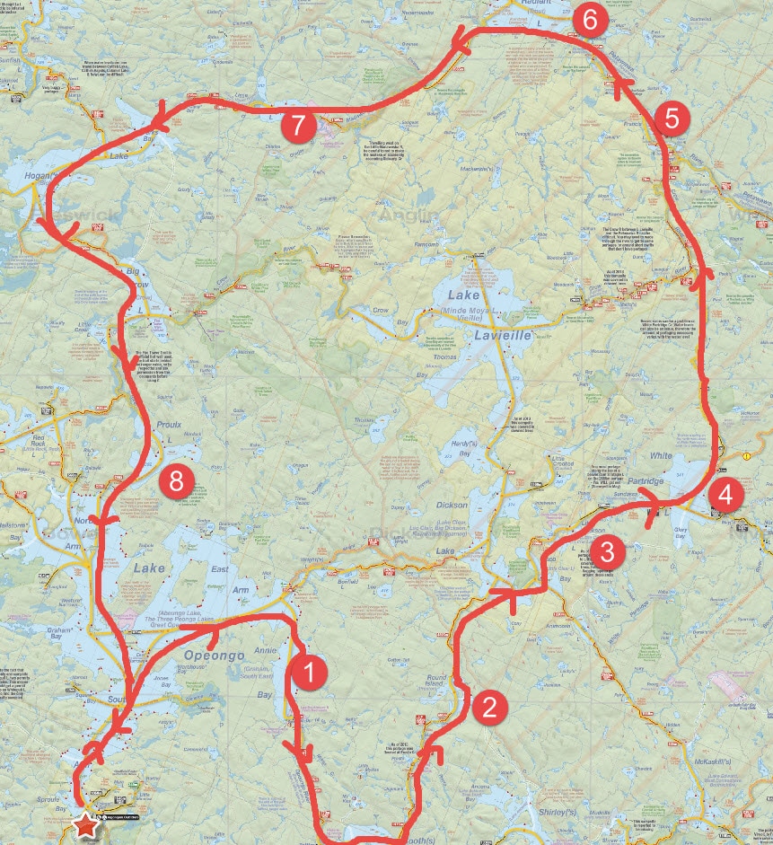
And I'm going to need the pack weight, me weight and fitness level changes for my Spring trip, because I've booked a fairly ambitious one. 
Picture
jeff's map - www.algonquinmap.com
9 days, solo. In/out through Opeongo with nights on Annie Bay, Round Island, Little Dickson, White Partridge, Francis, Radiant, Philip and Proulx. That works out to:

Total Paddling Distance: 123 KM
Total Portage Distance: 35.5 KM

For a total distance traveled of 158.5 KM over 9 days, or about 18 KM a day. Broken down like that it doesn't seem particularly rough, but not all days are equal. Annie Bay to Round Island, White Partridge to Francis and Philip to Proulx are likely going to be reasonably tough travel days. But each of those longer days is followed by a much easier one, so I think I'll be fine. I'm very much looking forward to it, now I just need Spring to get here. In the meantime I'll go back to reading trip reports and obsessing over my gear. 


2 Comments
jeff g
3/16/2017 12:12:43 pm

ambitious trip. looks great!

Reply
Bob Rasmussen
6/10/2017 11:40:57 pm

Looks like a great trip. It should be challenging. A couple of thoughts from me:

In two tries, my party never made it down White Partridge Creek to the Crow ... we could never find White Partridge Creek and turned back on both occasions. Instead, Lavielle and Dickson to the Crow is quite a bit more straightforward. Note that the 4895m from Round Island to Dickson is a challenging portage.

I guess the other major question is the direction of the loop. This way, you run a good chunk of the Petawawa and Madawaska (which are both good sized rivers) upstream. But you have the Crow and Opeongo River going downstream, so you have to choose I guess.

And the way you currently have it drawn, you have the Hogan - Big Crow 3750m in arguably the easier direction (long slow climb, quick descent rather than vice-versa). The combination of length of elevation gain and loss make it one of the more physically demanding portages in the Park.

Reply


Leave a Reply.

    Categories

    All
    Trip Log
    Yoke

    RSS Feed

Picture


​Links


Friends of Algonquin Provincial Park
Jeff's Maps
Algonquin Adventures Forum
Canadian Canoe Routes

Mark in the Park

Delta Kayaks
Mountain Science Research
Werner Paddles

  • Home
  • What's New
  • Trip Logs
    • 2018 - Achray - Clover - Tarn - St. Francis >
      • Part 2: Clover to Stratton
      • Part 3: Stratton, High Falls, St. Francis
      • Part 4: Barron Canyon
    • Rock - Louisa - Welcome
    • Opeongo - Catfish
    • Kiosk - Erables - Catfish - Cedar
    • Canoe - Joe - Burnt Island
    • Canoe - McIntosh - Shah
    • Shall - Booth - Shirley - McKaskill
    • Opeongo - Shippagew
    • Opeongo - Round Island >
      • Opeongo - Round Island Part 2
    • Magnetawan - Rosebary - Shah >
      • Magnetaway - Rosebary - Shah Part 2
    • Kiosk - Mouse - Maple >
      • Kiosk - Mouse - Maple Part 2
      • Kiosk - Mouse - Maple Part 3
    • 2017: One Day Failed Trip
  • Blog
  • Gear
    • Kayak Yoke
    • Camping Checklist
  • Photo Gallery
  • About
    • Contact